


-
[Weekly weather] Rain starts in May, but be careful of changeable weather in the second half of Golden Week
2024/04/28 23:00
-
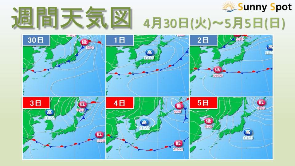
On the last day of April, the 30th (Tuesday), a front extending from the
low pressure system will pass over the Japanese archipelago.
Then, on May 1st (Wednesday), the area around Honshu will gradually become covered in high pressure, but
the front is expected to remain stationary for a long time in the east-west direction in the south of Japan.
From around the 2nd (Thursday) to the 4th (Saturday/holiday),
a low pressure system will move eastward over the southern front of Japan.
A low pressure system will pass near Sakhalin from the 3rd (Friday/Holiday) to the 4th (Saturday/Holiday).
The area around Honshu is expected to be covered by a
mobile anticyclone through the 5th (Sunday).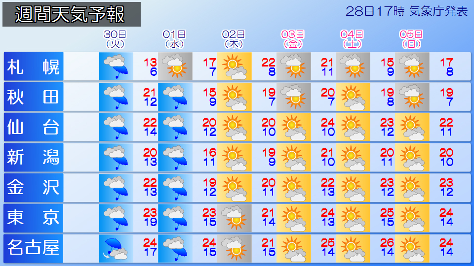
On the 30th (Tuesday), a developing low pressure system will advance from the Sea of Japan to Hokkaido.
As the front passes through the Japanese archipelago, it will rain across the country.
On the 1st (Wednesday), there will be some lingering rain on the Japan Sea side of northern Japan and eastern to western Japan at first, but the weather will gradually improve as a
high pressure system approaches from the west.
On the other hand, the Pacific side of eastern and western Japan will continue to have cloudy and rainy weather due to the influence of moist air blowing in from the
front.
The second half of the period will be sunny in many places, but due to the influx of warm, humid air and cold air in the upper atmosphere, there is a possibility of localized showers.
When going out, please be careful of the changeable weather.
Although the temperature will not be extremely hot,
some days are expected to reach a maximum temperature of 25c or higher, and
the sunny days are likely to be particularly sweaty and sunny.
Please be careful of heatstroke when participating in outdoor activities.
Okinawa will continue to have cloudy and rainy weather throughout the period.
-
Tomorrow, there is a risk of heavy rain in Okinawa. Be careful of heavy rain and thunderstorms in Amami and southern Kyushu as well.
2024/04/28 19:45
-
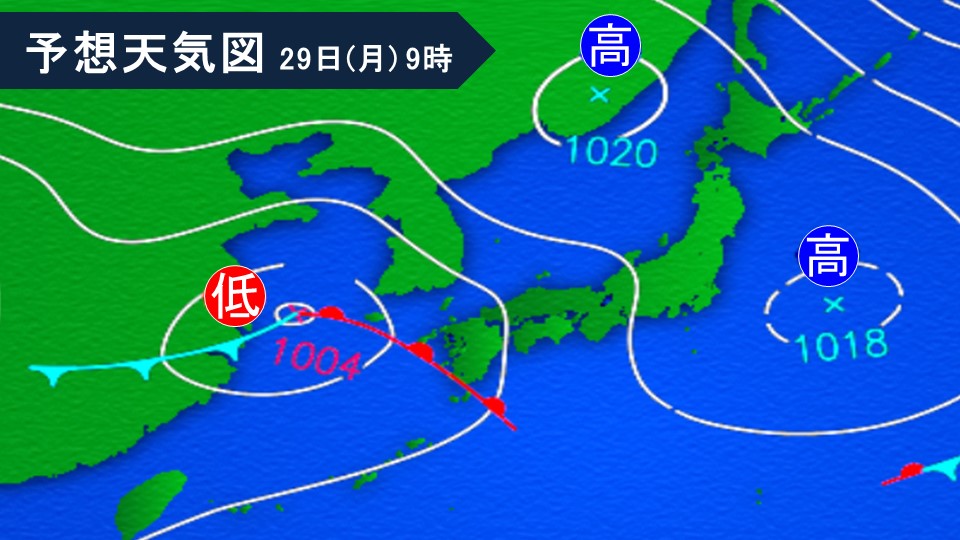
A low-pressure system located in China is expected to move toward the Tsushima Strait, accompanied by the
front, through tomorrow, the 29th (Monday).
Warm and humid air will flow towards fronts and low pressure systems,
Okinawa, Amami, and southern Kyushu will experience extremely unstable atmospheric conditions through tomorrow 29th (Monday). .
*Heavy rain
In the main island of Okinawa, heavy rain is expected to fall at the rate of 40mm per hour in many places until tomorrow, the 29th (Monday).
Depending on the degree of rain cloud development, there is a risk of
warning-level heavy rain.
Please be careful of landslides, flooding of low-lying areas, and rising river waters.
Forecasted rainfall for 24 hours until tomorrow evening (in heavy places)
Okinawa Main Island region 100mm
*Thunder and gusts
Sakishima Islands: Over the next day
Okinawa Main Island: Over the next day
Amami region: Late tomorrow night
Southern Kyushu: From early morning until late tomorrow
Cumulonimbus clouds will develop, and there is a risk of damage caused by violent gusts such as lightning and tornadoes.
Please be careful when doing outdoor activities.
Also, if there are signs that a developed cumulonimbus cloud is approaching,
please take precautions such as moving to a sturdy building.
Also, in the Daitojima region,
please be careful of lightning, gusts of wind, and sudden heavy rain into tomorrow.
-
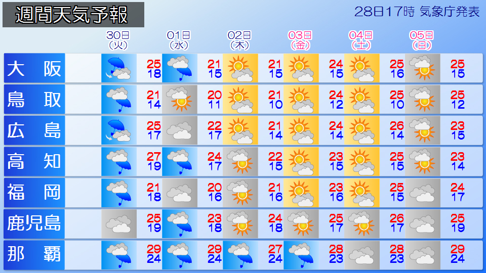
Golden week weather forecast. What is the weather like for the second half Announced on the 28th
2024/04/28 15:38
-
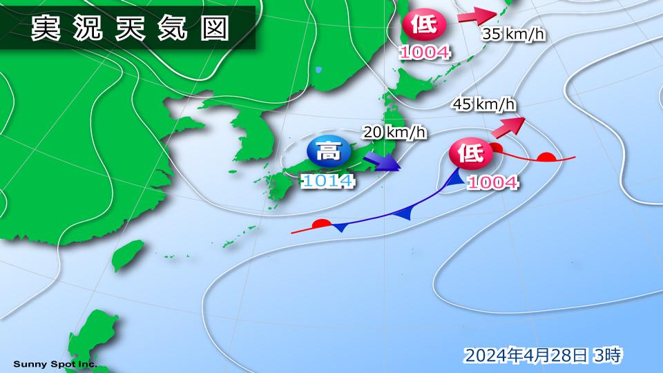
The area around Honshu is covered by high pressure moving eastward. Meanwhile, there is a low pressure system in central China that is moving eastward.
Although there are areas around Japan where there are a lot of clouds in Hokkaido and Kyushu, there are many places around the country that are sunny, especially from Tohoku to the Chugoku and Shikoku regions.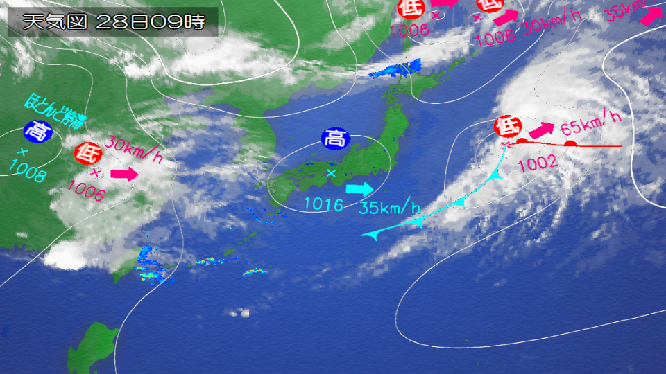
The temperature is also steadily increasing The temperature is rising, with summer days exceeding 25 degrees Celsius in many places.
Inland, there are places in midsummer where the temperature is over 30c, and many places have broken the highest temperature for April.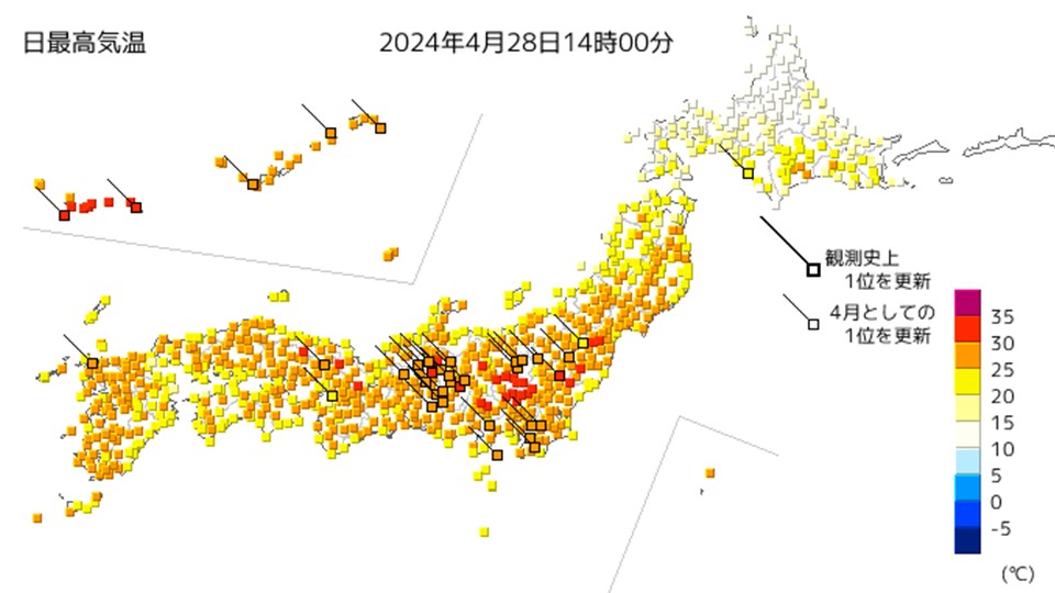
At the beginning of the holidays Yesterday and today were sunny and hot, but the weather is going downhill as a pressure trough and front approaches from the west.
It looks like it will rain tomorrow, mainly in western Japan.
Rain clouds are expected to spread to northern Japan the day after tomorrow, and from the 29th (Monday) to May 1st (Wednesday), many places across the country will experience severe weather.
then 4 By Midori-no-hi (Sunday (Saturday)), many places will be covered in high pressure and it will be sunny, and temperatures will rise, but not as much as today, so it looks like it will be a good day for tourists nationwide.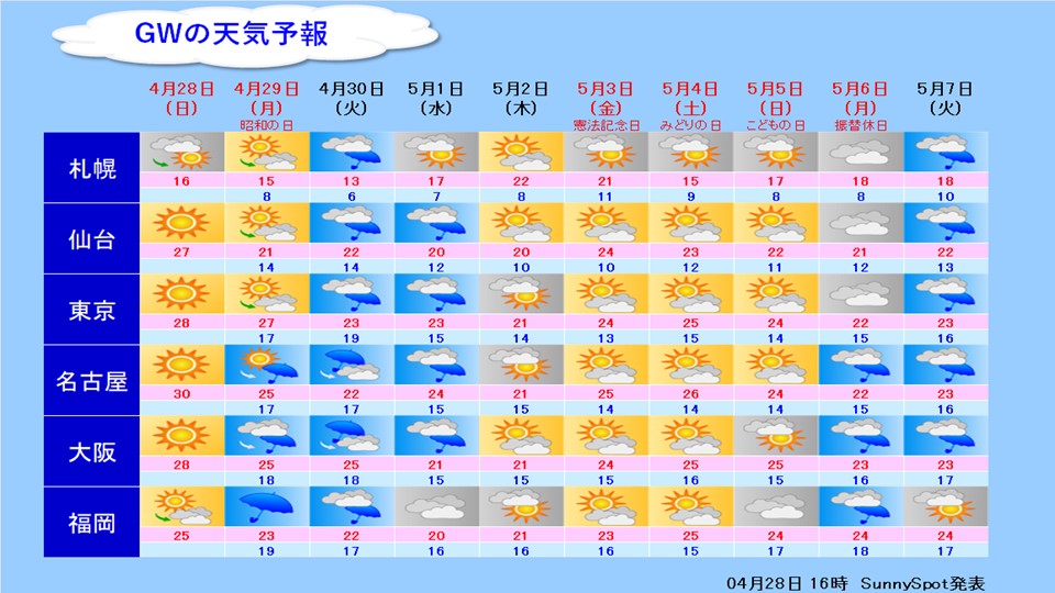
5th (Sun) ) The weather is expected to remain good on Children's Day, but a trough of atmospheric pressure is expected to approach, and the weather will go downhill. ), the weather is expected to deteriorate in many places due to the passage of a trough in atmospheric pressure.
-
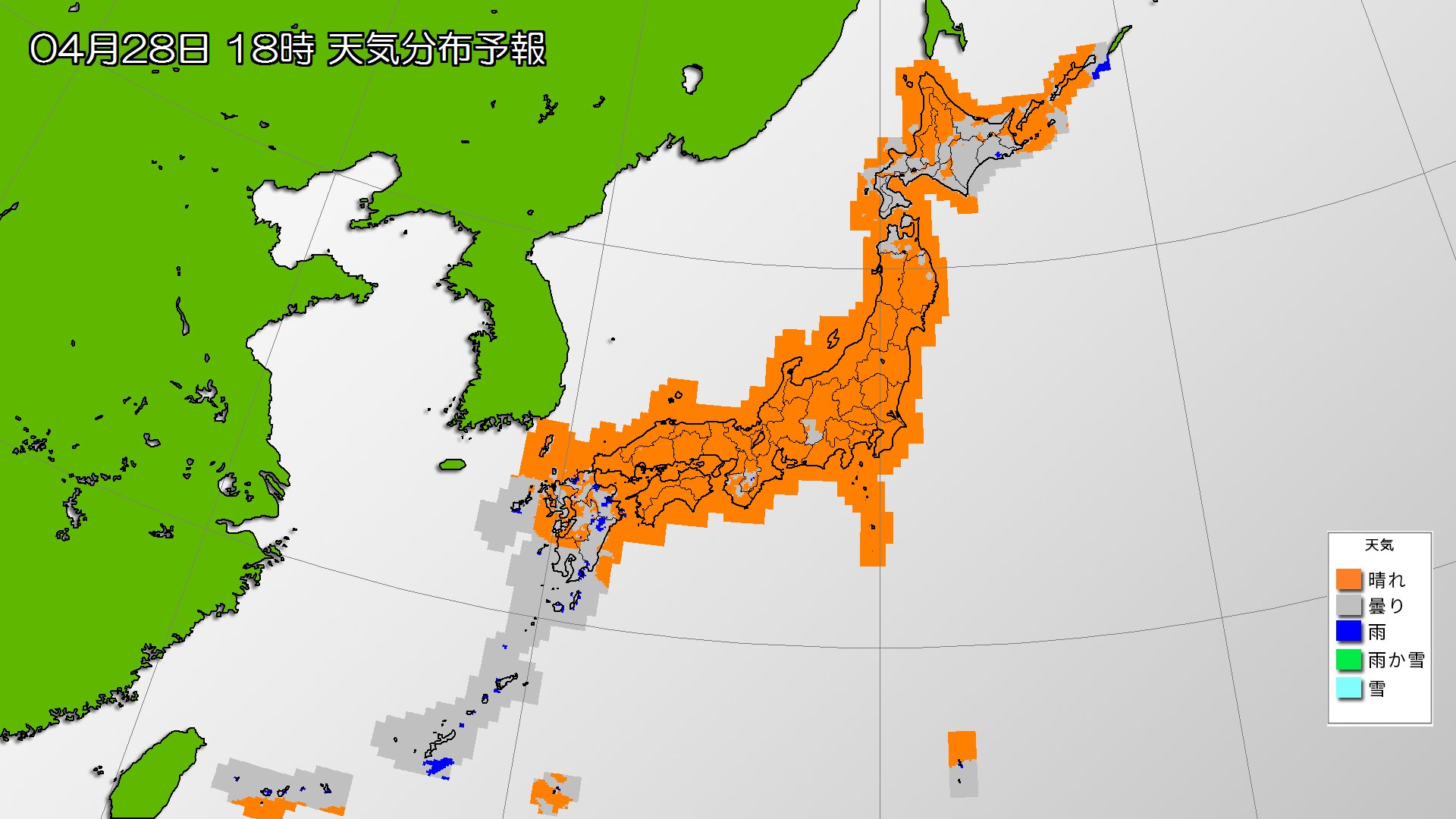
Today's weather: The sun is shining over a wide area, and the temperature is rising. There is a risk of heavy rain in the afternoon in Okinawa.
2024/04/28 06:56
-
Today, the 28th (Sunday), the area around Japan will be covered in high pressure and sunlight will likely reach a wide area. Meanwhile, rain is expected to gradually fall in the Nansei Islands near the front.
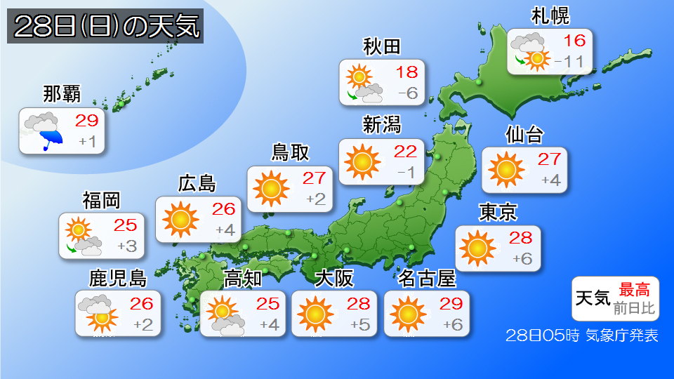
Clouds in Hokkaido The sky will be wide open, but there will be times when the sun will reach. Temperatures are expected to drop significantly compared to the previous day. The temperature difference will be large, so please be careful not to get sick.
It looks like the sun will be shining brightly in Tohoku. There will be some clouds in the afternoon, but it doesn't look like the weather will deteriorate.
It looks like clear blue skies will spread across eastern and western Japan.
Temperatures will rise during the day, and it is expected to be a summer day in many places. In some inland areas, it can be mid-summer, so please take precautions against heatstroke, such as drinking plenty of water.
Clouds will spread over Okinawa, and there will be places where it will gradually start to rain. Rain clouds are likely to develop in the afternoon, and depending on the degree of rain cloud development, there is a risk of warning-level heavy rain. Please be careful of landslides, flooding of low-lying areas, and rising river waters.
The maximum temperature is around 30c in many places, so it can feel damp.
-
Temperatures will drop in northern Japan tomorrow, unseasonably warm in various parts of eastern and western Japan, midsummer day forecast in Nagoya
2024/04/27 19:47
-
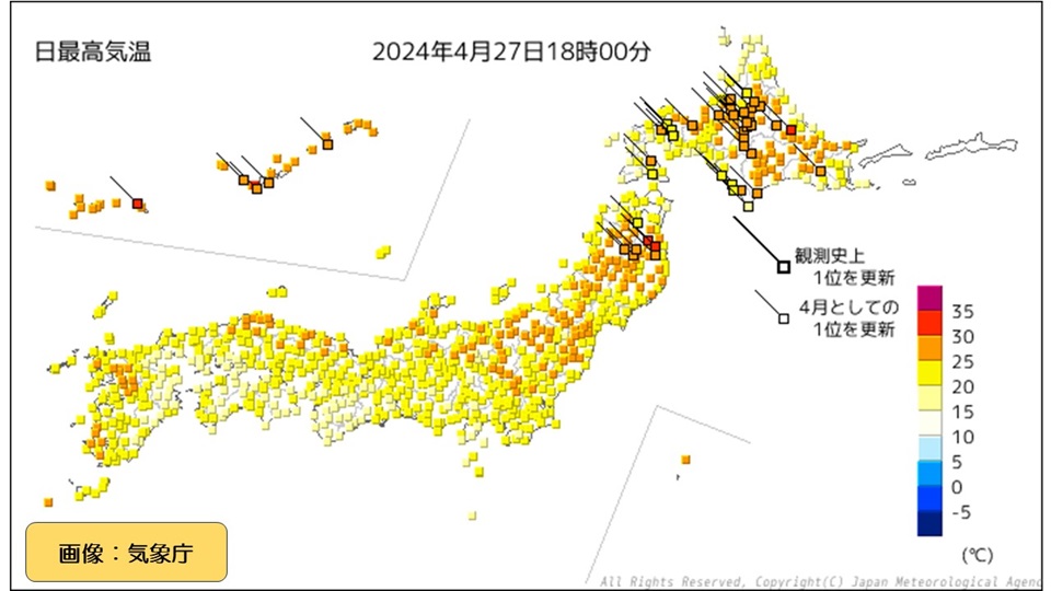
Today, it was sunny in northern Japan in the morning and the temperature rose, reaching 27.9c in Sapporo and 30.1c in Ikutawara, Engaru Town, Hokkaido, making it a midsummer day in some parts of Hokkaido.
The highest temperature in the country was observed in Sannohe, Sannohe-cho, Aomori Prefecture, at 31.2c, the highest temperature ever recorded for April.
Tomorrow, the air in northern Japan will change, and the temperature will likely drop in many places compared to today. Temperatures will continue to rise in many places in eastern and western Japan, and it will be necessary to take measures against the heat.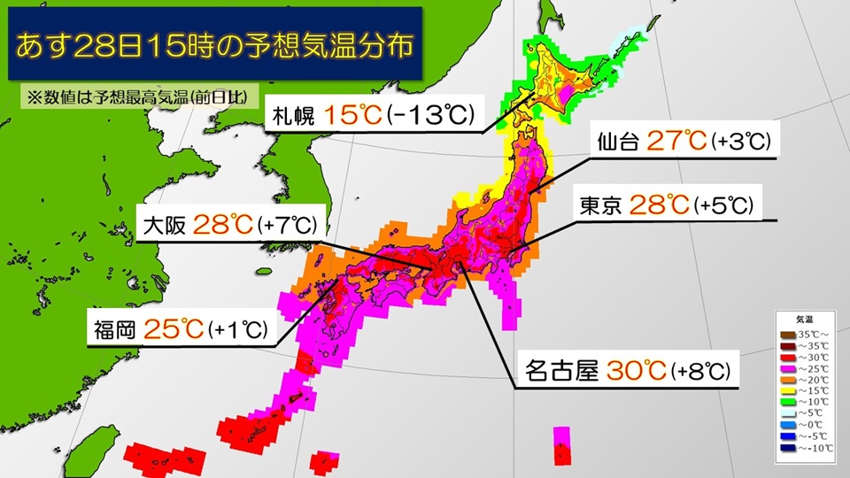
Northern Japan is warm In a complete change from today's airy weather, cold air is flowing in, and many places in Hokkaido and northern Tohoku are likely to experience temperatures below 20 degrees Celsius. In Sapporo, the temperature will only rise to 15c tomorrow, and the temperature difference is likely to be large. Please be careful not to get sick.
On the other hand, sunlight will reach a wide area from southern Tohoku to Kyushu, and temperatures are expected to rise during the day.
The predicted maximum temperature is 27c in Sendai (similar to late July), Tokyo 28c (similar to early July), and Osaka 28c (similar to mid-June), which is expected to be unseasonably warm in various places. In Nagoya, it is expected to be a midsummer day with temperatures expected to reach 30 degrees Celsius (same as early July).
This is the time when people are not yet accustomed to the heat, so it is necessary to take measures to prevent heat stroke, such as hydrating frequently and taking breaks when exercising outdoors or going out.
-
The first day of a three-day holiday is hot in northern Japan! Expected to be similar to late July in Sapporo
2024/04/27 09:03
-
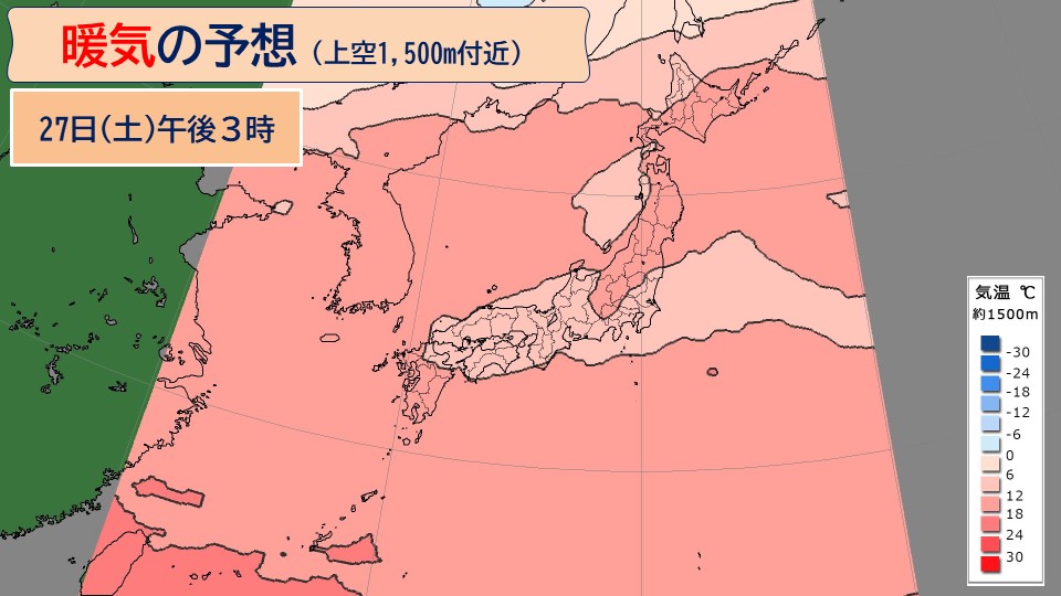
Today, the 27th (Saturday), the first day of a three-day holiday, temperatures are expected to rise significantly in northern Japan. The temperature is predicted to be 1500m above the ground, and air with a temperature of 12c or higher will flow all the way to Hokkaido. A temperature of 12 degrees Celsius at 1,500 meters above the ground means that there will be some places on the ground where the temperature will be over 25 degrees Celsius.
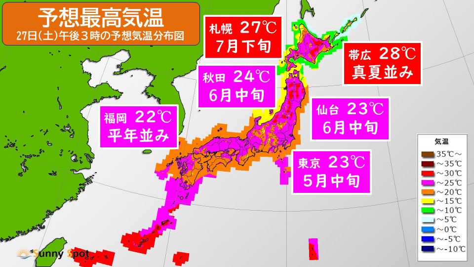
Today's sunny northern Japan So, in Sapporo it is 27c (like late July), Obihiro 28c (like midsummer), Akita 24c (like mid-June), Morioka 27c (like mid-July), and Sendai 23c (like mid-June). It looks like it will be unseasonably hot in many places.
I think many people will be going out from today as it is Golden Week, but please take precautions against heat stroke not only outdoors but also indoors, and be sure to stay hydrated and take adequate breaks.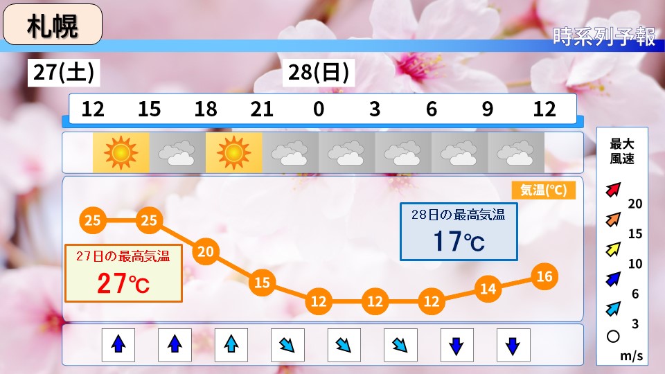
Tomorrow the 28th On Sunday, cold air will flow in from the Sea of Japan, causing temperatures to drop significantly in some parts of Hokkaido. The highest temperature in Sapporo is expected to be 17 degrees Celsius tomorrow. Temperatures are expected to drop by 10 degrees Celsius from today. You also need to be careful about fluctuations in temperature.
-
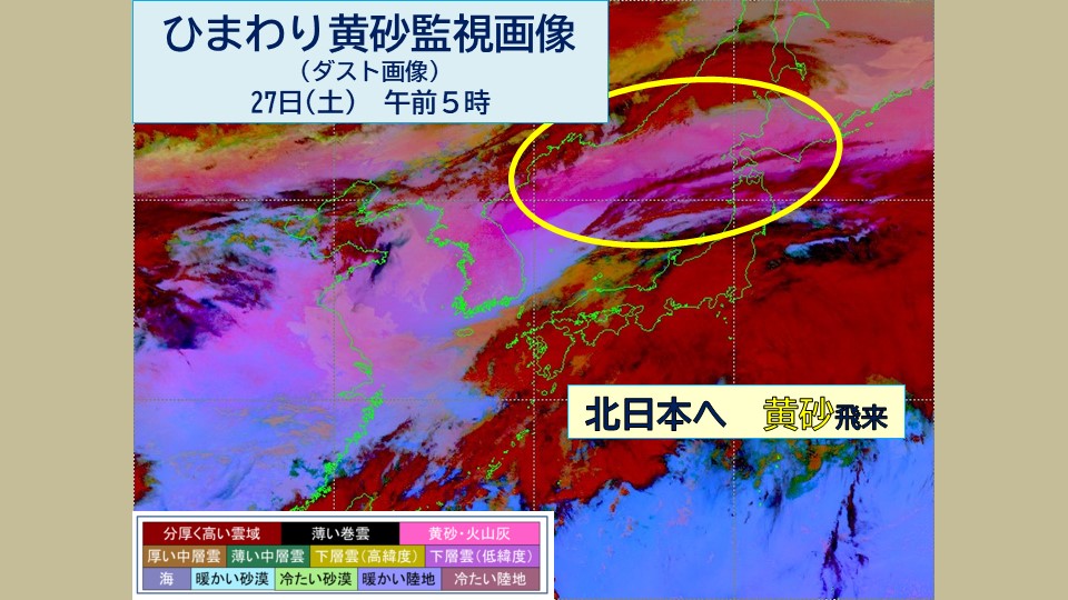
Be careful of yellow sand on the 27th (Saturday) as well, as visibility is less than 10 km in northern Japan.
2024/04/27 05:41
-
Yesterday, the 26th (Friday), yellow dust was observed in Tokyo. Looking at the Himawari Yellow Sand monitoring image (dust image) at 5 a.m. today, the 27th (Saturday), we can see that yellow dust is flying from the Sea of Japan to northern Japan.
Today, mainly in the morning, visibility is likely to be less than 10km in some places in northern Japan due to flying yellow dust. Care must be taken to avoid adhesion to cars and laundry and impact on traffic.
-
The first day of the long holiday, Okinawa and Amami are at risk of warning-level heavy rain, and the Pacific side is also not feeling refreshed.
2024/04/26 20:10
-
Golden week begins tomorrow, the 27th (Saturday). On the first day of the long holiday, the front will remain stationary from the Nansei Islands to the southern coast of Honshu, and a low pressure system will move eastward above the front.
Okinawa and Amami It will be rainy tomorrow, with the possibility of heavy rain of up to 40mm per hour, accompanied by thunder. There is a risk of warning-level heavy rain, so please be careful of landslides, flooding of low-lying areas, and rising river waters. You also need to be careful of lightning and gusts of wind.
On the Pacific side west of the Kanto region, clouds will likely spread, and it will rain in places. Although the rain is expected to last for a short time, it's a good idea to bring an umbrella with you when you go out.
On the other hand, there will be a lot of clouds on the Sea of Japan side at first, but the weather will gradually improve. It is expected that there will be many places in northern Japan that will receive sunlight.
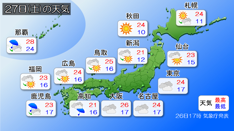
The predicted maximum temperature will be around 25c in eastern and western Japan, including 24c in Tokyo, Nagoya, and Hiroshima, and 26c in Osaka. Temperatures are also high in northern Japan, with Sapporo and Akita expected to reach 24c, much higher than normal. When going out, please take precautions against heat stroke.
-
Weather for Golden Week: Heat or rain Risk of stormy weather starting in May
2024/04/26 15:19

-
The long holidays start tomorrow!
This year, there will be 3 consecutive holidays in the first half, 4 consecutive holidays in the second half,
I think some people will have 10 consecutive holidays.
Let's take a look at the 10-day forecast as of today, the 26th, by day.
#Tomorrow, 27th (Saturday)
Nansei Islands - As the front stalls in the south of Japan, it will rain in Okinawa,
Clouds will spread over the Pacific side of Japan, from the west near the front to the east.
It looks like there will be some places where it will rain.
Temperatures will rise to around 25c during the day nationwide, and
Sapporo will be as hot as 24c, comparable to early July.
#The day after tomorrow, the 28th (Sunday)
It will continue to rain in Naha, but the area around Honshu is expected to be sunny and hot.
The peak of the heat during the first half of the holiday is expected to be on the 28th (Sunday), with temperatures expected to reach 29c in Nagoya and 27c in Tokyo and Osaka.
There are likely to be midsummer days with temperatures of over 30 degrees Celsius, so
Please take all possible measures to protect yourself from the heat.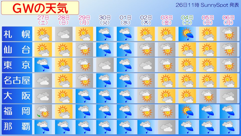
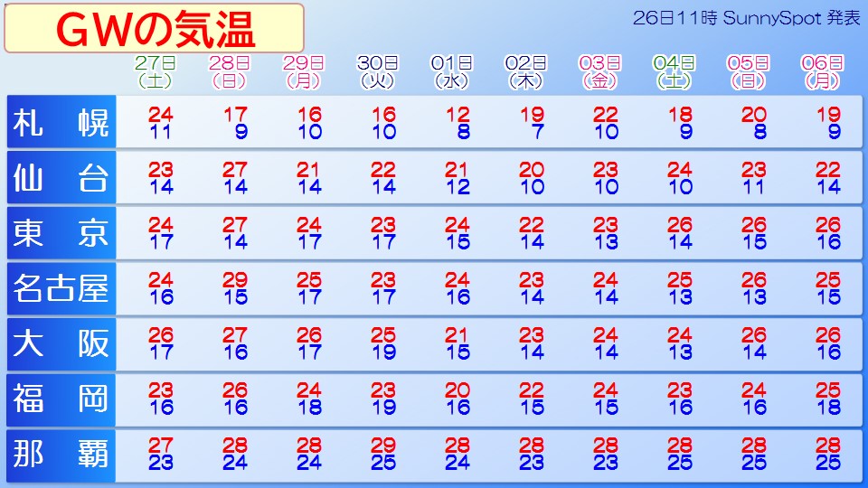
#29th (Monday/Showa-day's)
A low-pressure system has formed in the East China Sea, and rain is expected to start from the west, including Kyushu.
There will be a lot of clouds in eastern Japan, but there doesn't seem to be any major change in the weather.
#30th (Tuesday) - 1st (Wednesday)
A low pressure system will develop along Honshu and move northeast.
It is expected to rain across the country, and the wind is expected to increase throughout the day.
Due to the development of the low pressure system, there is a risk of stormy weather for the rest of the day, so please pay close attention to the latest information.
#2nd (Thursday) - 3rd (Friday, Constitution Day)
The front is stationary near Okinawa, and rain is expected to continue in Naha.
The area around Honshu is expected to be covered by high pressure from the north.
A cold wind is blowing from the northeast,
clouds are likely to spread, and it looks like it won't be clear and sunny over a wide area.
#4th (Saturday, Greenery Day) to 6th (Monday, substitute holiday)
A low pressure system is expected to move eastward with a front near the Nansei Islands.
As a result, rain is expected to continue in Kyushu and Okinawa.
As it continues to rain in Okinawa, you need to be careful about landslides and flooding of low-lying areas.
Also, a front will pass near Hokkaido, and there is a possibility of rain and thunderstorms around
4th (Saturday).
It will be sunny in other areas around Honshu, and it looks like summer days will continue during the day.
This year's Golden Week,
If it's sunny, you'll need to be careful of the heat,
If it's raining, you'll need to be careful of the "increasing rain and wind."
The weather during the holidays may still change significantly, so please check the latest weather information even during the
holidays.
-
Weather for Golden Week: Heat or rain Risk of stormy weather starting in May
2024/04/26 15:19
-
The long holidays start tomorrow!
This year, there will be 3 consecutive holidays in the first half, 4 consecutive holidays in the second half,
I think some people will have 10 consecutive holidays.
Let's take a look at the 10-day forecast as of today, the 26th, by day.
#Tomorrow, 27th (Saturday)
Nansei Islands - As the front stalls in the south of Japan, it will rain in Okinawa,
Clouds will spread over the Pacific side of Japan, from the west near the front to the east.
It looks like there will be some places where it will rain.
Temperatures will rise to around 25c during the day nationwide, and
Sapporo will be as hot as 24c, comparable to early July.
#The day after tomorrow, the 28th (Sunday)
It will continue to rain in Naha, but the area around Honshu is expected to be sunny and hot.
The peak of the heat during the first half of the holiday is expected to be on the 28th (Sunday), with temperatures expected to reach 29c in Nagoya and 27c in Tokyo and Osaka.
There are likely to be midsummer days with temperatures of over 30 degrees Celsius, so
Please take all possible measures to protect yourself from the heat.
#29th (Monday/Showa-day's)
A low-pressure system has formed in the East China Sea, and rain is expected to start from the west, including Kyushu.
There will be a lot of clouds in eastern Japan, but there doesn't seem to be any major change in the weather.
#30th (Tuesday) - 1st (Wednesday)
A low pressure system will develop along Honshu and move northeast.
It is expected to rain across the country, and the wind is expected to increase throughout the day.
Due to the development of the low pressure system, there is a risk of stormy weather for the rest of the day, so please pay close attention to the latest information.
#2nd (Thursday) - 3rd (Friday, Constitution Day)
The front is stationary near Okinawa, and rain is expected to continue in Naha.
The area around Honshu is expected to be covered by high pressure from the north.
A cold wind is blowing from the northeast,
clouds are likely to spread, and it looks like it won't be clear and sunny over a wide area.
#4th (Saturday, Greenery Day) to 6th (Monday, substitute holiday)
A low pressure system is expected to move eastward with a front near the Nansei Islands.
As a result, rain is expected to continue in Kyushu and Okinawa.
As it continues to rain in Okinawa, you need to be careful about landslides and flooding of low-lying areas.
Also, a front will pass near Hokkaido, and there is a possibility of rain and thunderstorms around
4th (Saturday).
It will be sunny in other areas around Honshu, and it looks like summer days will continue during the day.
This year's Golden Week,
If it's sunny, you'll need to be careful of the heat,
If it's raining, you'll need to be careful of the "increasing rain and wind."
The weather during the holidays may still change significantly, so please check the latest weather information even during the
holidays.