


-
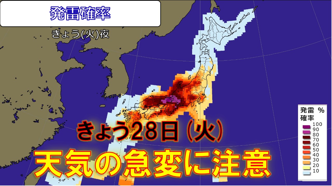
Today, the 28th (Tuesday) Atmospheric instability: warning for thunder, heavy rain, and sudden weather changes in eastern and western Japan
2026/07/28 11:56
-
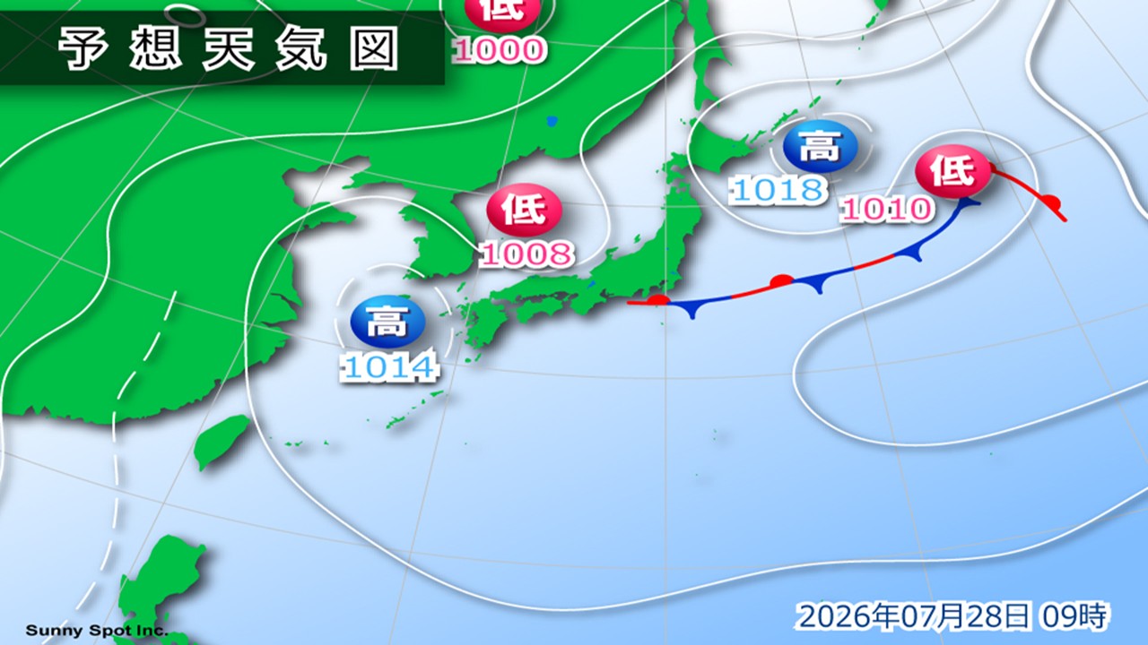
The front is extending from the Pacific coast of eastern Japan to the east of Japan, and is expected to remain mostly stationary until the 29th.
Also, a low pressure system in the Sea of Japan will approach the Hokuriku region on the night of the 28th, and another low pressure system is expected to form on the eastern front of the Kanto region on the morning of the 29th.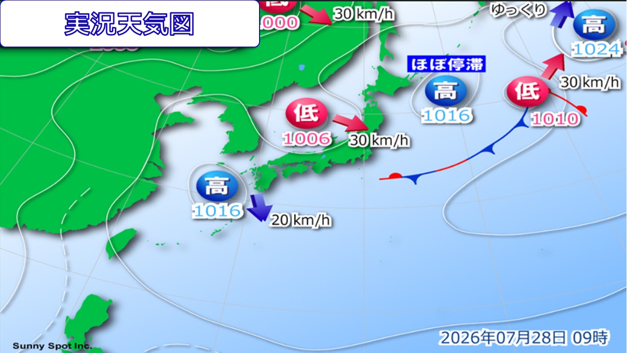
While warm, humid air is flowing towards the low pressure system and front,
at an altitude of approximately 6,000 meters, a pressure trough with cold air below -6 degrees Celsius will pass near Honshu into the 29th, and with the added influence of rising temperatures during the day, atmospheric conditions are expected to become extremely unstable from the Tohoku region to western Japan.
Eastern to western Japan will need to be careful of sudden changes in the weather today and tomorrow.
Be careful of sudden changes in weather from eastern Japan to western Japan. Particularly from the Tohoku region to eastern Japan, there will be localized heavy rain accompanied by thunder or extremely heavy rain, resulting in heavy rain in some places.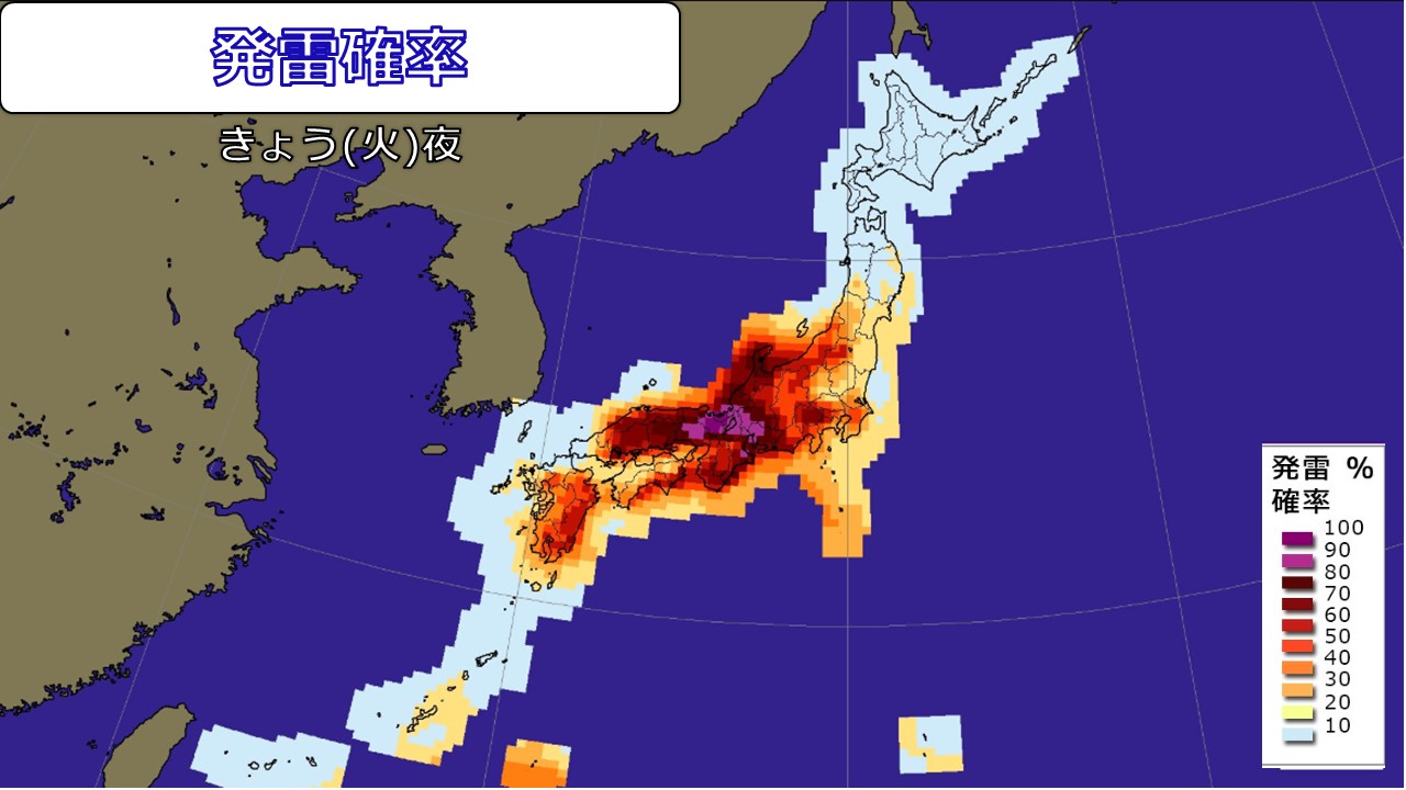
[Rain Forecast]
24-hour precipitation forecast from 6:00 am on the 28th to 6:00 am on the 29th (where there is a lot of precipitation)
Tohoku region 80mm
Kanto-Koshin region 120mm
Hokuriku region 150mm
Tokai region 120mm
Kinki region 100mm
br
Then, 24-hour precipitation expected from 6:00 on the 29th to 6:00 on the 30th (highest areas)
Tohoku region 80mm
Hokuriku region 100mm
There are areas where the ground has become loose due to previous heavy rains, so even a small amount of rain can increase the risk of landslides. Please pay attention to the latest information and be careful of landslides, flooding of low-lying areas, and rising river waters.
-
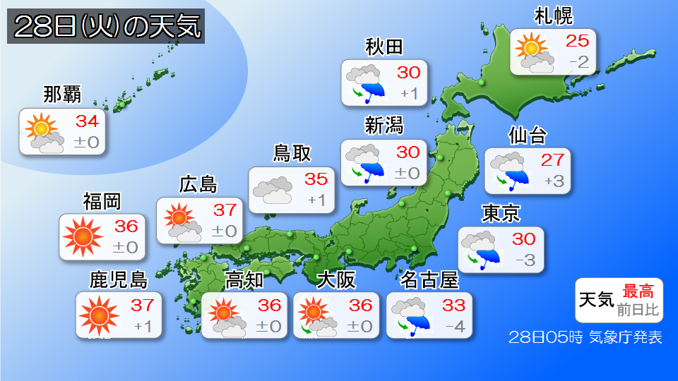
Weather forecast for today, the 28th (Tuesday): Western Japan is on alert for dangerous heat; Tohoku and eastern Japan are at risk of extremely heavy rain
2026/07/28 06:56
-
Today, the 28th (Tuesday), western Japan will continue to be covered in midsummer high pressure, resulting in severe heat.
Yesterday, the 27th (Monday), was an extremely hot day with temperatures reaching 40.0c in Hita City, Oita Prefecture. Today, the 28th, temperatures are expected to reach dangerously close to 40 degrees Celsius in some places, with temperatures expected to reach 39 degrees Celsius in Kurume City, Fukuoka Prefecture, and Hita City, Oita Prefecture. The heat will be dangerous, so please be extremely careful to avoid heat stroke. Rain clouds and thunderclouds are likely to develop in the afternoon due to rising temperatures and humid air, so please be careful of sudden changes in weather and severe thunderstorms especially in the inland and mountainous areas from Kinki to Kyushu.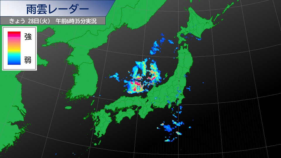
The area from Tohoku to eastern Japan will be affected by a low pressure system moving through the Sea of Japan and a front stationary to the east of Japan. Atmospheric conditions become extremely unstable due to the effects of cold air in the upper atmosphere, rising temperatures during the day, and humid air.
As of 6:30 a.m., rain clouds have developed over the Sea of Japan and are approaching the Hokuriku region. In Hokuriku, there are some places where it will rain from the morning, and there are likely to be places where there will be heavy rain accompanied by local thunderstorms.
In the afternoon, the rain is expected to spread further from Tohoku to eastern Japan, and there is a risk of extremely heavy rain with thunderstorms of more than 50mm per hour depending on the location.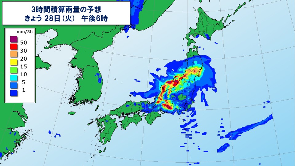
The ground is loose in some places due to the heavy rains so far, so please be careful of landslides, be careful of flooding of low-lying land, flooding of roads, rising water and flooding of rivers, and be careful of strong gusts of wind such as lightning and tornadoes. Please be sure to check the latest traffic information, as the period of heavy rain may overlap with the time of your return home.
-
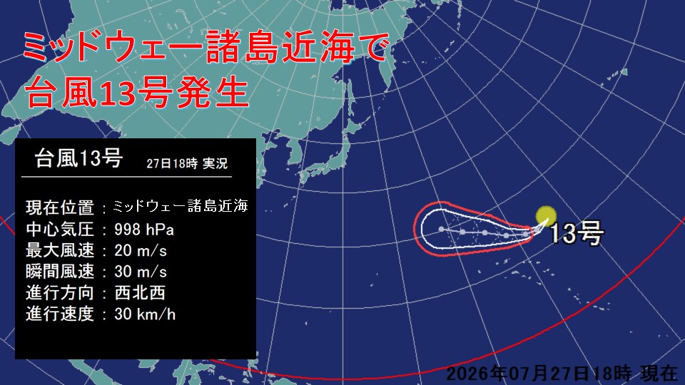
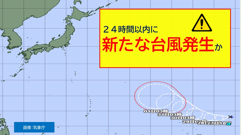
[Typhoon Information] Typhoon No. 13 (Dolphin) occurs near Midway Islands
2026/07/27 20:01
-
At around 3:00 pm today, the 27th (Monday), the tropical cyclone moving near the Midway Islands became a new typhoon, No. 13.
#Typhoon No.13 As of 6:00 p.m. on the 27th (Monday)
==================
Center location Near Midway Islands
Travel speed West-northwest 30km/h
Central pressure 998hPa
most Large wind speed: 20 m/s (near the center)
Maximum instantaneous wind speed: 30 m/s
===================
Typhoon No. 13 is moving westward near the Midway Islands as of 6 p.m. It will continue to move westward as it continues to develop, reaching the sea near Minamitorishima around 3pm on the 1st, and is expected to become a "very strong" force with a central pressure of 925 hPa, a maximum wind speed of 50 m/s near the center, and a maximum instantaneous wind speed of 70 m/s.
Typhoon No. 13 is moving westward through areas with high sea surface temperatures, so it is likely to further intensify after the 1st and become a "ferocious" force with maximum wind speeds of over 54m/s near the center. If this typhoon moves near the center of the forecast circle in the future, it may pass through the Ogasawara Islands and approach Japan, causing a major impact. Please pay attention to the latest typhoon information that will be updated in the future.
-
Weather for tomorrow 28th (Tuesday): Heavy rain warning for Tohoku and eastern Japan
2026/07/27 17:57

-
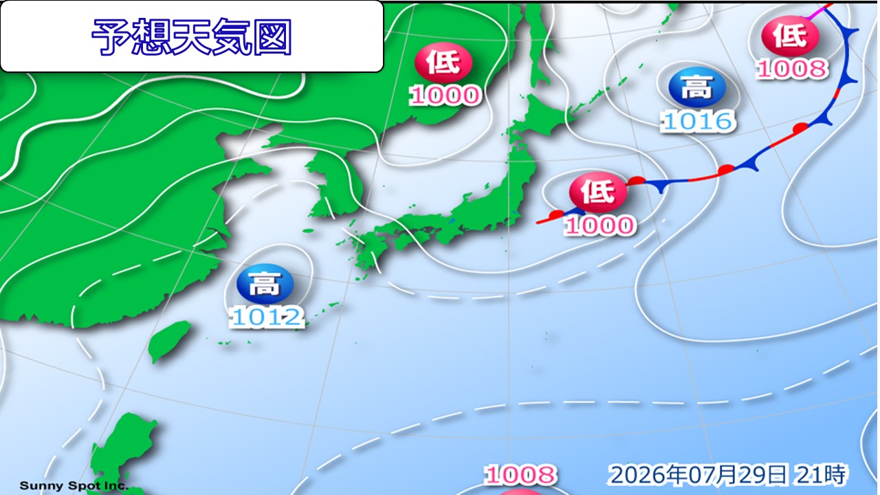
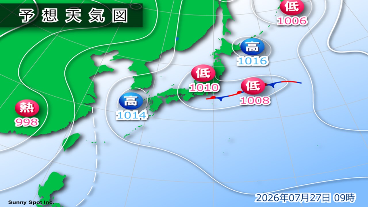
The high pressure system is expected to retreat to the west, and the seasonal rain front is expected to move southward to the Kanto coast. Additionally, a low pressure system is expected to move southeast from the Sea of Japan.
The area of rain will expand tomorrow, and there is a risk of short-term heavy rain, lightning, and gusty winds in Tohoku and eastern Japan. It will start to rain in the afternoon, and in places it will rain heavily in the evening and early evening. Please don't forget to bring your umbrella.
Western Japan is expected to continue to experience strong sunlight and extreme heat. The further west you go, the more intense the heat will be. There is a possibility of showers in the evening in the Kinki and Sanin regions. It's safe to have an umbrella.
There are many places in Hokkaido that are covered by high pressure and receive sunlight. During the day, the temperature will rise to around 25 degrees Celsius, making it very hot.
-
[Typhoon information] New typhoon expected to occur by tomorrow 28th (Tuesday) Be careful of future course
2026/07/27 07:55
-
The Japan Meteorological Agency announced today, the 27th (Monday), that a tropical cyclone near the Midway Islands is expected to develop into a typhoon. After this, it will continue to develop and move westward, becoming a strong force on the 31st.

As of 6 a.m. today, Monday, the 27th, there is a tropical cyclone near the Midway Islands, and it is moving west. The Japan Meteorological Agency announced that this tropical cyclone is expected to develop into a typhoon within the next 24 hours.
This tropical cyclone, which will turn into a typhoon, will move westward over the Marshall Islands on the 29th and will reach the waters near Wake Island on the 30th. It is expected to become a strong force on the 31st, and further strengthen as it moves northwest until August 1st. The future course has not yet been determined, but we need to pay close attention to trends.
Please check the latest typhoon information from time to time.
-
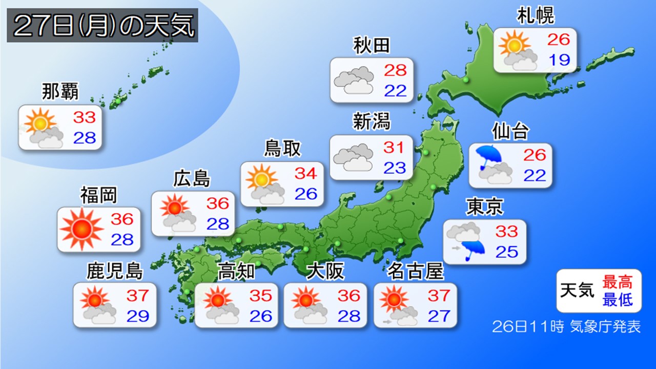
Weather for today, the 27th (Monday): Extreme heat continues west of the Tokai region. Atmosphere is unstable in western and eastern Japan.
2026/07/27 07:30

-
Today, the 27th (Monday), it will be cloudy and rainy in many places in the San'in, Hokuriku, Kanto-Koshin and Tohoku areas, and there will be some places where it will rain very heavily with thunder, mainly in the morning in the San'in and Hokuriku areas, and in the afternoon in the Kanto and Tohoku areas. The sun will reach other areas, and the intense heat is likely to continue.
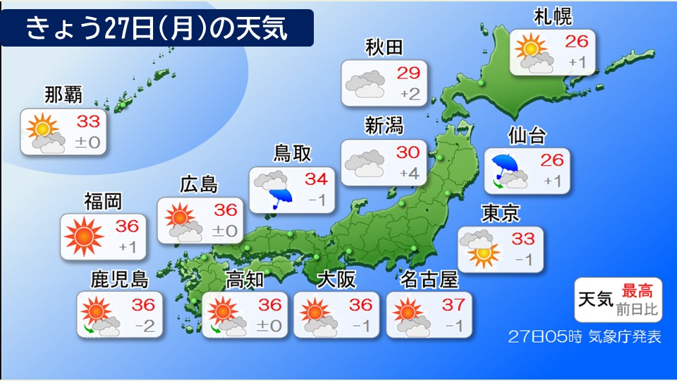
Tokai and western Japan will experience intense heat today, with many places experiencing extremely hot days with temperatures exceeding 35c. Temperatures are expected to reach 39 degrees Celsius in places like Hita in Oita Prefecture, Kurume and Saga City in Fukuoka Prefecture, and the temperature is expected to reach dangerously close to 40 degrees Celsius.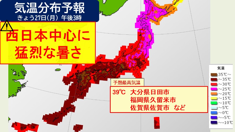
However, atmospheric conditions are expected to be unstable in various places. In particular, thunderclouds are likely to develop in the morning from the San'in region to Hokuriku, and in the afternoon from the Pacific side of western Japan to the Tohoku region, and heavy rain is likely to occur in some places, especially in the Kanto region. Be careful of landslides and flooding of low-lying land.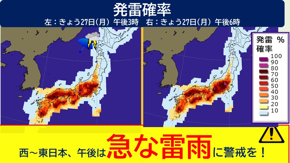
In addition, some places in Hokuriku and Tohoku are experiencing record heavy rain for July. The ground is loose in some places, so you need to be on guard against landslides.
-
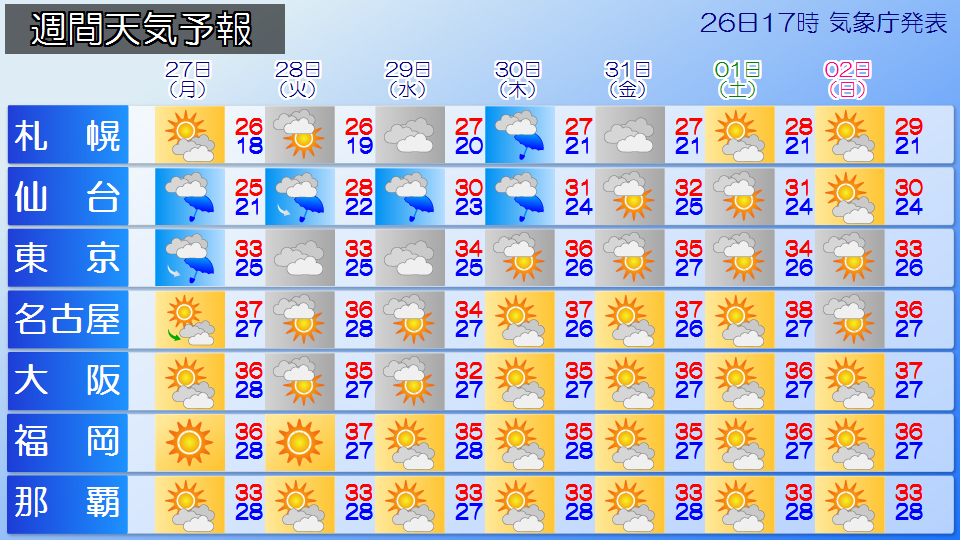
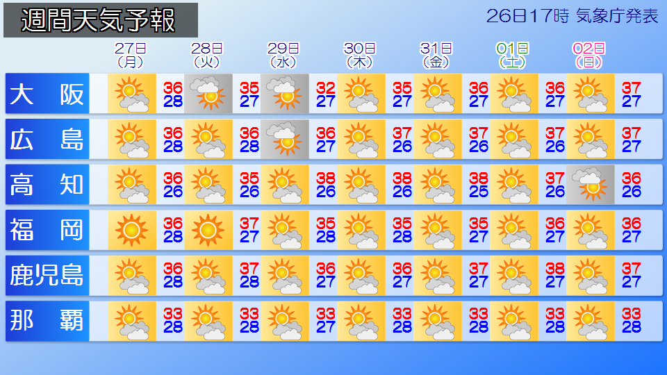
Weather for the week: Be careful of heavy rain at the end of the rainy season in Tohoku and Hokuriku; severe heat continues from Kanto to Kyushu every day
2026/07/26 18:30
-
From now on, fronts and low pressure systems will pass through northern and eastern Japan, and there will be many days when the weather is likely to stagnate. Additionally, due to rising temperatures and humid air during the day, you should be careful of sudden rain and thunderstorms in the afternoon.
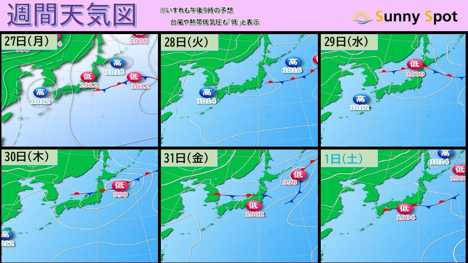
Tomorrow, the 27th (Monday), it will rain in some places in Tohoku and Hokuriku through the morning, but the area of rain will gradually become narrower, but the sky pattern is likely to continue with clouds easily spreading.
In the afternoon, rain clouds and thunderclouds are likely to develop mainly in the inland areas of Honshu and along the mountains. Even if it's sunny when you go out, the weather can change suddenly in the afternoon, so be careful of sudden rain or thunderstorms that fall in a short period of time.
Tohoku and Hokuriku areas are likely to experience continued cloudy and rainy days due to fronts and low pressure systems. A low pressure front is expected to pass near northern Japan around the 29th (Wednesday). After that, the front is expected to stay near Tohoku-Hokuriku until around the 31st (Friday), and there will be warning-level heavy rain from the Sea of Japan side of Tohoku to the vicinity of Niigata Prefecture, and total rainfall will increase in some places.
The ground has become loose in some places due to heavy rain, and even with light rain, landslides are more likely to occur, so please be careful.
Around the 1st (Saturday), the influence of the front will be less and the Tohoku and Hokuriku regions are expected to have many sunny days. It looks like the rainy season will finally end in Tohoku and Hokuriku next month.
The severe heat will continue from Kanto to Kyushu, and western Japan will be covered in midsummer high pressure, with temperatures rising to nearly 35 degrees Celsius every day. Depending on the location, there may be places that record extremely hot days with temperatures exceeding 40 degrees Celsius. Also, the temperature will not drop at night and the tropical nights will continue. Regardless of day or night, please be extremely careful to avoid heat stroke, drink plenty of water and salt, and use air conditioning indoors to prevent heat.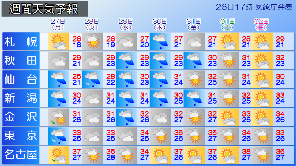
-
Weather for tomorrow 27th (Monday): Unrefreshing weather in Kanto and Tohoku
2026/07/26 17:53
-
The front will move eastward to the east of Japan, but atmospheric conditions are expected to be unstable mainly in the Kanto and Tohoku regions. On the other hand, western Japan and the Nansei Islands will continue to be within an area of high pressure.
The Kanto, Tohoku, and Hokuriku regions are likely to have cloudy weather tomorrow as well. There is a possibility of sudden rain and thunderstorms in the Kanto and Tohoku regions from the afternoon. Please take an umbrella with you when you go out. In Hokuriku, there is a period of time when the rain stops temporarily around noon, but it will continue to rain intermittently.
It is expected that the summer sky will continue to expand from the Tokai to the west. The weather is expected to be extremely hot, so please be extremely careful about heatstroke.
There are many places in Hokkaido that receive sunlight. The temperature is around 25c in many places, so it looks like it will be a pleasant day.
-
Weather for tomorrow 27th (Monday): Unrefreshing weather in Kanto and Tohoku
2026/07/26 17:51
-
The front will move eastward to the east of Japan, but atmospheric conditions are expected to be unstable mainly in the Kanto and Tohoku regions. On the other hand, western Japan and the Nansei Islands will continue to be within an area of high pressure.
The Kanto, Tohoku, and Hokuriku regions are likely to have cloudy weather tomorrow as well. There is a possibility of sudden rain and thunderstorms in the Kanto and Tohoku regions from the afternoon. Please take an umbrella with you when you go out. In Hokuriku, there is a period of time when the rain stops temporarily around noon, but it will continue to rain intermittently.
It is expected that the summer sky will continue to expand from the Tokai to the west. The weather is expected to be extremely hot, so please be extremely careful about heatstroke.
There are many places in Hokkaido that receive sunlight. The temperature is around 25c in many places, so it looks like it will be a pleasant day.
-
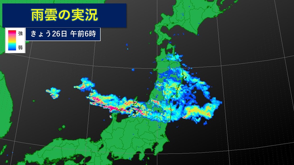
Front becomes more active; extremely heavy rain is likely in Hokuriku and Tohoku; strict warning against landslides
2026/07/26 06:57
-
The front is extending from the Sea of Japan to the Hokuriku and Tohoku regions. Atmospheric conditions are extremely unstable near the front, with active rain clouds forming from the Sea of Japan south of the front to the Hokuriku region, and extremely heavy rain of 51.0 mm per hour has been observed in Miomote, Murakami City, Niigata Prefecture.
Today, the 26th, the atmospheric conditions will be extremely unstable mainly in the Hokuriku region, with heavy rain of over 30 mm per hour accompanied by lightning, and extremely heavy rain of over 50 mm per hour expected to occur in some places. Heavy rain continues in the Tohoku and Hokuriku regions, and there is a possibility that the total amount of rainfall will increase into tomorrow, the 27th (Monday).
Also, on the Pacific side of eastern Japan to the south of the front, warm, humid air will flow into tomorrow, the 27th (Monday), and with the added influence of rising temperatures during the day, atmospheric conditions will become extremely unstable, and heavy rain is expected to occur in some places, accompanied by thunder.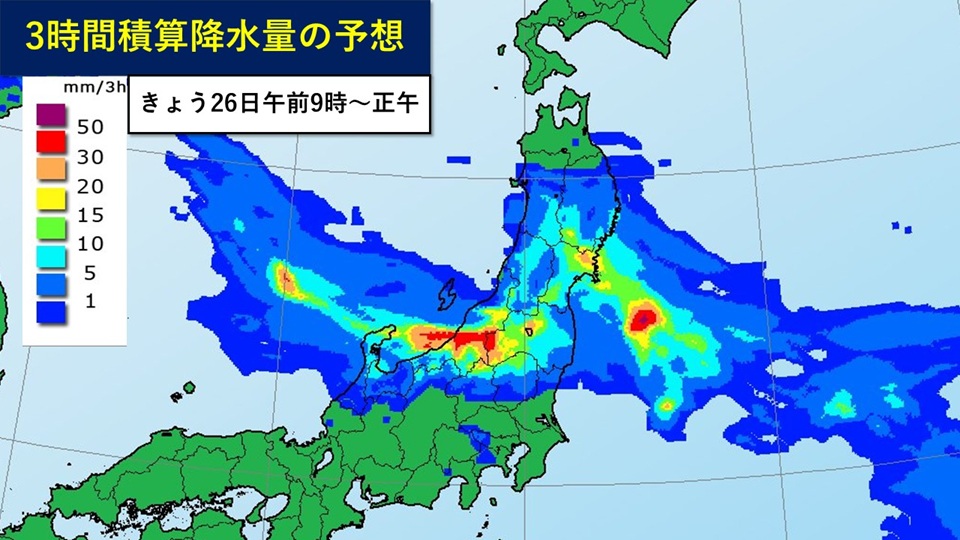
#Forecasted amount of rain (in areas where there is a lot)
+Precipitation expected for 24 hours by 6:00 tomorrow 27th (Monday)
Tohoku region 100mm
Kanto-Koshin region 80mm
Hokuriku region 120mm
As of tomorrow Precipitation expected for 24 hours by 6:00 on the 28th (Tuesday)
Tohoku region 60mm
#Disaster prevention matters
In the Hokuriku and Tohoku regions, today, the 26th, please be extremely cautious of landslides, and be careful of flooding of low-lying areas, rising water levels, and flooding of rivers. In the Tohoku region and the Kanto-Koshin region, please be careful of landslides, flooding of low-lying land, and rising river waters until tomorrow the 27th (Monday).
Also, please be careful as there is a risk of strong wind gusts such as lightning and tornadoes. There is also a risk of hail, so please be careful when managing crops and agricultural facilities.